Skip to content
Facebook
X-twitter
Newsletter
Interactive Map
Events
Search
Search
Home
Plan your visit
Countryside Code
Cycling
Discovery Centre and Tourist Information
Getting around
Access for All
Driving
Public Transport
Horse riding
Starting Points
Discovery Centre
Holme Cultram Abbey
Campfield Reserve
Places to Explore
Nature Reserves
Bowness Gravel Pits
Crosscanonby Carr
Drumburgh
Finglandrigg Wood
Glasson Moss
Mawbray Banks
Orton Moss
RSPB Campfield
Watchtree
Wedholme Flow
Coast
England Coast Path
Grune Point
The Solway Dunes
Salt Marsh
Museums and Exhibitions
Discovery Centre
Holme Cultram Abbey
Maryport Aquarium
Maryport Maritime Museum
Solway Wetlands Centre
Senhouse Roman Museum
Tullie House Museum and Art Gallery
Gateway Towns
Aspatria
Carlisle
Maryport
Silloth
Wigton
Historic Hamlets
Allonby
Burgh by Sands
Boustead Hill
Bowness on Solway
Newton Arlosh
Port Carlisle
Historic Sites
Holme Cultram Abbey
King Edward 1st Monument
Milefortlet 21
Salt Pans
Things to do
Beachcombing
Cycling
Exploring Nature
Exploring History
Local food and drink
Swimming and Watersports
Walking
A Special Place
Landscape
Patterns on the Landscape
Special Characteristics
Ecology
Environments
Coast and Dunes
Lowland Raised Mires
Salt Marsh
The Firth
Wildlife
Birds
Insects and Invertebrates
Mammals
Marine and Seashore
Plants, Flowers and Fungi
Reptiles and Amphibians
Heritage
Prehistoric
Roman
Medieval
Early Modern
20th Century
Wartime
Buildings
Churches
Farmsteads
Fortifications
Vernacular and Clay Dabbins
Working Landscape
Energy
Farming
Fishing
Tourism
Our Work
What is an NL
Management Plan
Projects
Joint Advisory Committee
Farming in Protected Landscapes
What the programme will Fund
Eligibility
How to Apply
Partnerships
Nature Recovery
Silloth and Mawbray Dunes and Dune Heath
Meet The Team
Publications
Video Gallery
Get Involved
Events
Volunteering
Newsletter
FAQs
Social Media
Contact us
Menu
Home
Plan your visit
Countryside Code
Cycling
Discovery Centre and Tourist Information
Getting around
Access for All
Driving
Public Transport
Horse riding
Starting Points
Discovery Centre
Holme Cultram Abbey
Campfield Reserve
Places to Explore
Nature Reserves
Bowness Gravel Pits
Crosscanonby Carr
Drumburgh
Finglandrigg Wood
Glasson Moss
Mawbray Banks
Orton Moss
RSPB Campfield
Watchtree
Wedholme Flow
Coast
England Coast Path
Grune Point
The Solway Dunes
Salt Marsh
Museums and Exhibitions
Discovery Centre
Holme Cultram Abbey
Maryport Aquarium
Maryport Maritime Museum
Solway Wetlands Centre
Senhouse Roman Museum
Tullie House Museum and Art Gallery
Gateway Towns
Aspatria
Carlisle
Maryport
Silloth
Wigton
Historic Hamlets
Allonby
Burgh by Sands
Boustead Hill
Bowness on Solway
Newton Arlosh
Port Carlisle
Historic Sites
Holme Cultram Abbey
King Edward 1st Monument
Milefortlet 21
Salt Pans
Things to do
Beachcombing
Cycling
Exploring Nature
Exploring History
Local food and drink
Swimming and Watersports
Walking
A Special Place
Landscape
Patterns on the Landscape
Special Characteristics
Ecology
Environments
Coast and Dunes
Lowland Raised Mires
Salt Marsh
The Firth
Wildlife
Birds
Insects and Invertebrates
Mammals
Marine and Seashore
Plants, Flowers and Fungi
Reptiles and Amphibians
Heritage
Prehistoric
Roman
Medieval
Early Modern
20th Century
Wartime
Buildings
Churches
Farmsteads
Fortifications
Vernacular and Clay Dabbins
Working Landscape
Energy
Farming
Fishing
Tourism
Our Work
What is an NL
Management Plan
Projects
Joint Advisory Committee
Farming in Protected Landscapes
What the programme will Fund
Eligibility
How to Apply
Partnerships
Nature Recovery
Silloth and Mawbray Dunes and Dune Heath
Meet The Team
Publications
Video Gallery
Get Involved
Events
Volunteering
Newsletter
FAQs
Social Media
Contact us
Home
>
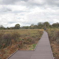
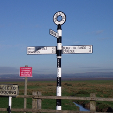
Getting around
Facebook
Twitter
Home
Plan your visit
Countryside Code
Cycling
Discovery Centre and Tourist Information
Getting around
Access for All
Driving
Public Transport
Horse riding
Starting Points
Discovery Centre
Holme Cultram Abbey
Campfield Reserve
Places to Explore
Nature Reserves
Bowness Gravel Pits
Crosscanonby Carr
Drumburgh
Finglandrigg Wood
Glasson Moss
Mawbray Banks
Orton Moss
RSPB Campfield
Watchtree
Wedholme Flow
Coast
England Coast Path
Grune Point
The Solway Dunes
Salt Marsh
Museums and Exhibitions
Discovery Centre
Holme Cultram Abbey
Maryport Aquarium
Maryport Maritime Museum
Solway Wetlands Centre
Senhouse Roman Museum
Tullie House Museum and Art Gallery
Gateway Towns
Aspatria
Carlisle
Maryport
Silloth
Wigton
Historic Hamlets
Allonby
Burgh by Sands
Boustead Hill
Bowness on Solway
Newton Arlosh
Port Carlisle
Historic Sites
Holme Cultram Abbey
King Edward 1st Monument
Milefortlet 21
Salt Pans
Things to do
Beachcombing
Cycling
Exploring Nature
Exploring History
Local food and drink
Swimming and Watersports
Walking
A Special Place
Landscape
Patterns on the Landscape
Special Characteristics
Ecology
Environments
Coast and Dunes
Lowland Raised Mires
Salt Marsh
The Firth
Wildlife
Birds
Insects and Invertebrates
Mammals
Marine and Seashore
Plants, Flowers and Fungi
Reptiles and Amphibians
Heritage
Prehistoric
Roman
Medieval
Early Modern
20th Century
Wartime
Buildings
Churches
Farmsteads
Fortifications
Vernacular and Clay Dabbins
Working Landscape
Energy
Farming
Fishing
Tourism
Our Work
What is an NL
Management Plan
Projects
Joint Advisory Committee
Farming in Protected Landscapes
What the programme will Fund
Eligibility
How to Apply
Partnerships
Nature Recovery
Silloth and Mawbray Dunes and Dune Heath
Meet The Team
Publications
Video Gallery
Get Involved
Events
Volunteering
Newsletter
FAQs
Social Media
Contact us
Menu
Home
Plan your visit
Countryside Code
Cycling
Discovery Centre and Tourist Information
Getting around
Access for All
Driving
Public Transport
Horse riding
Starting Points
Discovery Centre
Holme Cultram Abbey
Campfield Reserve
Places to Explore
Nature Reserves
Bowness Gravel Pits
Crosscanonby Carr
Drumburgh
Finglandrigg Wood
Glasson Moss
Mawbray Banks
Orton Moss
RSPB Campfield
Watchtree
Wedholme Flow
Coast
England Coast Path
Grune Point
The Solway Dunes
Salt Marsh
Museums and Exhibitions
Discovery Centre
Holme Cultram Abbey
Maryport Aquarium
Maryport Maritime Museum
Solway Wetlands Centre
Senhouse Roman Museum
Tullie House Museum and Art Gallery
Gateway Towns
Aspatria
Carlisle
Maryport
Silloth
Wigton
Historic Hamlets
Allonby
Burgh by Sands
Boustead Hill
Bowness on Solway
Newton Arlosh
Port Carlisle
Historic Sites
Holme Cultram Abbey
King Edward 1st Monument
Milefortlet 21
Salt Pans
Things to do
Beachcombing
Cycling
Exploring Nature
Exploring History
Local food and drink
Swimming and Watersports
Walking
A Special Place
Landscape
Patterns on the Landscape
Special Characteristics
Ecology
Environments
Coast and Dunes
Lowland Raised Mires
Salt Marsh
The Firth
Wildlife
Birds
Insects and Invertebrates
Mammals
Marine and Seashore
Plants, Flowers and Fungi
Reptiles and Amphibians
Heritage
Prehistoric
Roman
Medieval
Early Modern
20th Century
Wartime
Buildings
Churches
Farmsteads
Fortifications
Vernacular and Clay Dabbins
Working Landscape
Energy
Farming
Fishing
Tourism
Our Work
What is an NL
Management Plan
Projects
Joint Advisory Committee
Farming in Protected Landscapes
What the programme will Fund
Eligibility
How to Apply
Partnerships
Nature Recovery
Silloth and Mawbray Dunes and Dune Heath
Meet The Team
Publications
Video Gallery
Get Involved
Events
Volunteering
Newsletter
FAQs
Social Media
Contact us
What Is An AONB
Newsletter
Map
Search
Search
Close this search box.
Events
Getting Around
Access For All
Driving
Public Transport